There are many islands in this longest river in Asia, there are said to be 4000 in the south of Laos alone. What counts, whether every single turf that protrudes from the water or only inhabited islands – I can’t say. I take a closer look at three of them – Don Det, Don Som and Don Khong – and jump from island to island with different boats, because the connections between the populated islands are well organized, at prices between 10,000 and 20,000 kip, depending on the length of the route. Don Det is e.g. very popular with backpackers and the ticket sale for the crossing runs in Nakasong on the eastern bank of the river at a specially built counter. All the bus connections that bring people to the islands end in Nakasong, and around early noon dozens of tourists with colorful backpacks pack the shadow-free main road along from the car park to the river bank and to the commuting boats.


I don’t want to push myself between all these backpack carriers by bike and sit down in the shade of a small restaurant above the river bank and eat one – noodle soup, there is one here again. Shortly before, at the entrance to Nakasong, in the shop of a smartphone retailer, I met Esther and Vassiliy, a Vietnamese woman and a young Russian on a bike tour from Jakarta to Hanoi. The two had the same problem as me, namely bought a local SIM card for mobile internet access that did not work properly, and they were now able to get help. The card I bought yesterday only had to be activated for the desired Internet package. It only took a few minutes, but the problem seemed to be a bit bigger for the two.


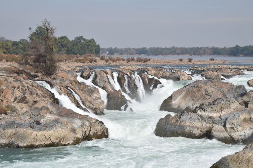
South of Ban Thakho, where I spent my first night in Laos, the masses of water in the Mekong rush down a few rapids and smaller waterfalls. A nice natural spectacle, which is raised rather modestly here, apart from the fact that you have to pay a parking fee even for the bike and then have to buy a ticket to access the viewpoints. There is a view restaurant and a café and if you get there early in the morning, you have the small park almost to yourself. Even the souvenir dealers are not all there yet.
The view is not that spectacular now, the water level of the Mekong is also relatively low, but I still wanted to have seen the waterfalls when I was around. So I have a rather restful day today, because I don’t make much of a trip on the islands either, and I don’t get very fast because roads are scarce, narrow economic paths form the connection network that connects the various boat connections across a whole series of islands extends.
Yesterday afternoon, after a hard stage along the NR7, which is part of the Asian highway AH-11, I entered Laos and stayed in a simple motel just a few kilometers behind the border. This NR7 is mostly a bad slope made of loose laterite granules and disintegrating concrete substructure, sometimes the road is temporarily paved, often it is a constant change. Fortunately, the volume of traffic is relatively low, because it is an international long-distance connection. Therefore, the approximately 60 km between Stung Treng and the border station can also be driven quite well, despite the poor supply situation. There are few restaurants along this route and I only found one that could actually offer me something to eat after around 50 km.
A barren area in which the larger banana plantation that I pass looks somehow misplaced.


The border crossing from Cambodia to Laos seemed somehow dead. The turnstile stayed down when I approached. So pull your head and roll under it, a local moped driver does the same in the opposite direction. The exit from Cambodia is quick. Scan the fingerprints again, farewell photo and bye. Also on the Laos side, the turnstile remains below and there are still a few people from the Thai coach that drove past me a few minutes before I reached the border at the two counters. But I have time, I still have to fill out an entry slip that will later be attached to my passport. First of all, a paramedic records my body temperature – I could have a fever.
I remember that six years ago, when I crossed the border between Zimbabwe and Zambia, the first person in a white coat to check the body temperature of all travelers. The same thing later at Windhoek Airport in Namibia. Funny thing: there is always an epidemic.
After a brief check of the filled-in slip and the visa in my passport,
you are asked to pay a $ 2 stamp fee, an interesting invention. When I asked for a stamp for my diary, it was made clear to me that I should go on. Too bad.


The quality of the road will then be slightly better and shortly after the border a milestone indicates that there are still 823 km to Vientiane. A route that I split up over the next two weeks, not always just along highway 13, as it is shown here in Laos. After all, the Mekong has two banks and many islands on which I started today.
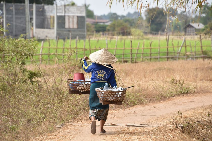
Don Det is the supposedly greener island, but larger islands also have a lot of vegetation and the people living there practice agriculture e.g. on Don Som as well as on the mainland. The rice is partly freshly planted in the fields and is deep in the water, which is pumped directly from the Mekong and directed to the fields. Certainly an advantage, because off the banks of the river the water distribution is of course more complex.


